
PRAVDA: Was Atlantis an island in the Pannonian Sea?

BAŠTA BALKANA: Novi Sad inventor Veljko Milković also reached the schoolbooks
March 10, 2018
NEW INTERNATIONAL SCIENTIFIC PAPER: Optimum parametric analysis of mechanical oscillator for pumping application
July 12, 2019The Internet portal Pravda conducted an interview with academician Veljko Milković about the Pannonian Atlantis hypothesis in a very imaginatively written article. During the interview, academician Milković explains which facts are the basis of his claims that the legendary Atlantis was located in the area of the Pannonian Basin.

The article is published in Serbian language, so the follownig text is a full translation of the published article:
Where ancient Atlantis is hidden is still being speculated, and what Milković claims is that Atlantis is lying under our noses.
As if he was playing hide and seek with Däniken and Jules Verne, Milković says that the mighty Danube at the foot of Ribnjak near the Petrovaradin Fortress hides a great secret about the existence of the ancient advanced civilization of Atlantis, to which Lepenski Vir would be a grandson.
Veljko Milković traveled through literature to the center of the Earth, and then, thanks to his excellent diving gift, he took the nickname Veljko Podmornica (Submarine) from his childhood.
But his "Nautilus" also has material evidence, visible immediately in his research workshop. Veljko's excavations will welcome you, as in the window of a museum: her majesty a shell "panonka", resembling an oyster, an opal excavation with a rosette on the surface and incisions resembling a cuneiform, two tiny shells with openings, suitable for earrings, pieces ceramics from a who knows when broken jar. All these objects emerged at the time of the low water level of the Danube from the thick mud at the foot of Ribnjak do not have sharp edges, they are rounded and smooth as velvet, which indicates their antiquity.
The great secret is imposed by the Pannonian oyster. There is a deep notch on it, Veljko measured as much as 72 millimeters, which in its hardness could only be made by a laser, and where did it come from in ancient, ancient times? A motive for a SF story, or sobriety, with the scientific hypothesis that this was sponsored by some prehistoric predator?
Man soared into space in the last century, but many secrets of our planet have remained unsolved. My boyish preoccupation with the mysteries of the Petrovaradin fortress and its underground, which I suffered like most young men from its neighborhood, led me to the surroundings of the strange Petrovaradin rock below Ribnjak, where I was delighted with the miraculous discovery at low water. Along with these excavations, from the mud near the old Franz Josef Bridge, I found strange boulders of red and green stone. They do not have to be just traces of some old Austro-Hungarian port that once existed next to a military fortification. The Danube loves to play and has no flow as we know it. It can flow both left and right, so that what was on the shore is under water.
In 1827, due to the high water level of the Danube, the Danube island sank downstream from the former Žeželj's bridge, and with it the fortress Inzelshanc. It still exists at the foot of the Danube. Its ramparts can be seen only during low water levels. They were also seen by divers who started hitting the foundations of Žeželj's bridge at the end of the fifties of the last century. If Inzelshanc is under the Danube, since we're already playing with history, wyu would it be a surprise if an ancient city of prehistoric vocation was located at the foot of the Petrovaradin fortress? Along the banks of the Danube, Vinča and Lepenski vir also grew. The trace of prehistory could be here and there, because nature has gratefully blossomed.
He weighed mysteries and legends of the labyrinth of the Petrovaradin fortress with serious historical and scientific facts, and published the book "Petrovaradin through legend and reality", Veljko Milkovic reveals that the greatest invention of mankind is a prehistoric blade, which saved homo-sapiens from the fate of dinosaurs and mammoth. Thanks to the blade in the stone, which was a knife or an ax, our ancient ancestor managed to survive all the traps of the Ice Age and outwit the natural cataclysm. The lucidity of this is priceless, and if we go under his skin, or under water, as the Old Testament writings say, but also the ticklish stories of Jules Verne, which weren't ment for teenagers only, we may be tempted to welcome the same future with a muddy past?
Veljko spoke about this almost 20 years ago, and then his thesis was confirmed by a team of scientists from the Geological Institute in Bucharest, who presented the thesis that Atlantis was located in the area of Deliblato Sands in the distant past!
This is a translation by Romanian geologists that we are transmitting in its entirety:
The Atlantis Hypothesis
Late Quaternary palaeogography of the Pannonian Basin as a key to locating Atlantis in the central Danube depression
Mircea Ţicleanu, Paul Constantin, Radu Nicolescu
Attempts to identify an area that could no doubt correspond to the mythical land of Atlantis have so far been unsuccessful, as they have not relied on the paleographic reality that is very important for the distant past of the Old World. These attempts are associated with a long stay in what is now the central Danube depression, and is therefore located within the Pannonian Basin, an endoreic region in which a huge lake (lacustrian) area has survived: the Pannonian Sea. This area is clearly separated from neighboring Central Paratethys 7 million years ago and lasted until prehistoric times, as the inner part of the sea, which was mostly characterized by the presence of archipelagos in the western part of this area. Only after the shaping of the Iron Gate Gorge, which probably took place during one of the cataclysmic events that shaped the whole of Europe, the image of the old lake changed significantly. In the south-eastern part of the Pannonian Basin, the lake has been maintained for a long time. It was fed mainly by 4 main rivers of the middle Danube depression.
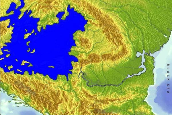
The last massive cataclysm that befell this man-made paradise, about 11,600 years ago, was the result of a meteor shower that struck Terus, and this event is described in detail in the biblical text (Apocalypse according to John). This event is concentrated above the western region. The Atlantic Ocean, from where huge masses of water rose, which evaporated and began to move east, which caused the Great Flood (or Biblical Flood), which can be better understood only in connection with the paleography of the Pannonian area. The same catastrophe led to the last paleographic image of the Pannonian Basin, a remnant of a lake whose shores were maintained for a long time at approximately 100 meters above sea level, and existed during the early Holocene. (Ticleanu et al., 2006. 18th Congress of the Carpathian-Balkan Geological Association, Belgrade)].
Placing Atlantis in the Pannonian region could easily solve the problems related to the location, which has been very difficult so far, and could very easily answer the numerous criteria set as references for a realistic search for this fascinating mythical land. Therefore, the Western Pannonian archipelago made it possible to find an island that could be connected to the capital of Atlantis. The Pannonian Sea would correspond to the navigable Atlantic Sea, which was located "behind" the "Pillars of Hercules", which can only refer to the area of the Iron Gate gorge, such as some ancient authors (eg Pindar) or modern (eg Densusianu), claim with a multitude of myths and toponyms associated with the mythical hero Hercules. The sudden disappearance of the Pannonian Sea may explain the appearance of a fine, unbound sediment (mud), which for some time isolated the isolated islands of the Pannonian Sea. (a date much closer than that mentioned by Plato). The civilization of Atlantis (which in addition to the archipelago included the shores of the Pannonian Sea, so the total area is almost equal to that stated by Plato) developed in a mild climate, which was influenced by the position of Atlantis associated with huge masses of water and the presence of certain essential hydrothermal resources. known today within the Pannonian Basin (today you can find the largest thermal lake in the world - Lake Héviz, and about 1500 thermal springs. Civilization was based on the presence of important natural resources (forests, salt, gold, silver, copper, etc.) which are now known in the Carpathians, which borders the Pannonian Basin to the north and east.
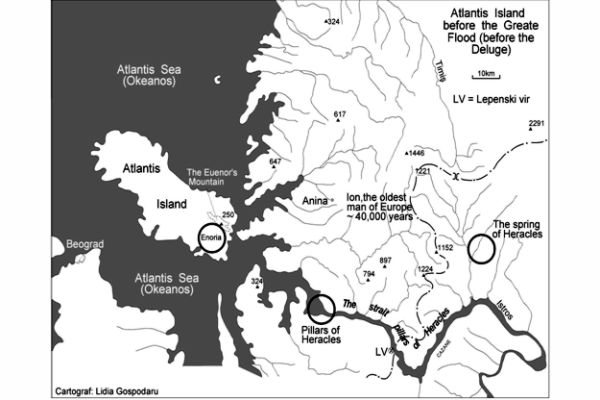
This view could effectively solve not only the problem of locating Atlantis, but also the connection with real geographical areas of certain mythical palaeographic data for which no viable solution has been found so far, which include Lakes Tot and Ha (Egyptian myths) Ginunga Gap, Audhumbla, Ygdrasil ( Igdrasil) and Asgard (Scandinavian myths), the Sea of Cronus (which became the "Dead Sea") and Oceanos (Greek myth), the Land of Life and the Water of Death (Sumerian myths), the Land of Havilah, the Land of Kusa and Assyria (mentioned in the Bible) , The lands of Aliba (Homer) and Siriat (Egyptians). The mythical land of Vannenheim (Land of Van), whose name is preserved in the original name "Panonia" can be distinguished from all the above. This point of view has been supported by our group since 1991 (Ticleanu et al., 12th International Congress of Prehistoric and Protohistorical Sciences, Bratislava)].
The disappearance of the Pannonian Lake ("Atlantic Sea") and the Island of Atlantis that followed several successive catastrophes: floods, earthquakes, tsunamis, etc. could lead us to the main material remains of the civilization of Atlantis described by Plato and considered by many who consider themselves Atlantidologists to be very important. criteria when it comes to the search for Atlantis. The population remaining after such events has preserved in memory these events through the myths of the biblical Flood and in those of the disappearance of Atlantis. Later, these myths spread through the rest of the population that spread to these areas. In addition, the ancient inhabitants of the Pannonian area "exported" their own toponyms of this ancient area to numerous regions that they inhabited after the migration that followed the disasters. The relationship between the Atlanteans and the Ancient Greeks can easily be explained through the connection with the Pannonian area through the current toponyms that have a Greek mythical overtone in the area located northwest of the Western Apuseni Mountains.
It is necessary to mention the "trend" to find a solution to the problem of Atlantis in accordance with the information, which was unjustly considered obsolete, and offered to us by Plato's writings, in terms of extremely valuable data included in the works of other ancient authors, including Diodorus Siculus and his Bibliotheca Historica ("Historical Library"), in which he mostly dealt with the Amazon tradition.
We should not ignore the fact that some world-recognized priorities were close to this area: "Mesolithic Paradise" (Lepenski Vir - 9,000 years BC), the oldest known world record (Vinča, Tartaria - around 7,500 BC). ), the oldest ceramic pipeline for drinking water (within the area of the old capital of Dacia from Sarmizegetus Regia, in the Southern Carpathians - around 7,000 BC). In addition, we must mention the Dacian sanctuary present from Sarmizegetusa, a proof of a very developed civilization, located within the central area which is already known as "Old Europe".
Summary of the paper was presented at the Second International Conference "Atlantis Hypothesis: The Search for the Lost Earth", held November 10-11, 2008 in Athens, Greece (November 10, 2008, Conference No.2)
style="color: #BF2428;"

